Date: 8/13 – 8/14/2022 Who: myself Length: about 13 miles Weather: mild, clear sky, calm, rainy overnight
This was an overnight backpacking hike in the Lost Creek Wilderness. The hiking route forms a loop, with mostly uphill gains to reach the campsite, and downhill for the return to the trailhead. It was a good challenge!
It rained a-lot overnight. But, my equipment did its job well and I stayed dry and warm.
Date: 6/3/2021 Who: myself Length: about 10.8 miles (5.4 up + 5.4 down) Time: 9.5 hours Weather: mild, clear sky, calm
It has been awhile, and I’m not in the best shape. Surprisingly, I was able to summit Mt. Elbert, my 11th fourteener! I camped at Lakeview Campground, just above Twin Lakes. Then, drove early in the morning a short distance to the upper trailhead of South Elbert Trail (about 10,500 ft. elevation). I started at 2 AM with a headlamp. I encountered snow at about 12,000 feet, but was prepared with microspikes. I lost the trail at about 13,000 feet due to more snow, but followed the tracks that had been made by others. I reached the summit (14,433 ft.) at about 7 AM. Mt. Elbert is the highest point in Colorado.
On the way down, I felt a little altitude sickness. I just took it slow and kept hydrated to overcome the queasy stomach. Otherwise, I felt ok physically. It was really nice to get back out in the mountains!
view West from the summitview of Mt. Massive from the summit of Mt. ElbertMt. Elbert viewed from Twin Lakes
Date: 8/28/2018 Who: myself Length: about 4.5 miles (2.25 up + 2.25 down) Time: 2 hours Weather: cloudy, windy, rainy, cool
This hike was during the trip to Ireland last Summer with my mom. Croagh Patrick is known as Ireland’s holy mountain, because Saint Patrick is reputed to have fasted and prayed on the summit. When I realized that we were so close to this famous mountain, I knew that I wanted to hike it if possible.
The day started with a 15 minute taxi ride from our hotel in Westport, County Mayo to the trailhead. I hiked alone up the trail, and into the clouds to reach the summit. There is a chapel on the summit, but it was closed and locked. The weather worsened during the time on trail, and it was raining gently for the descent.
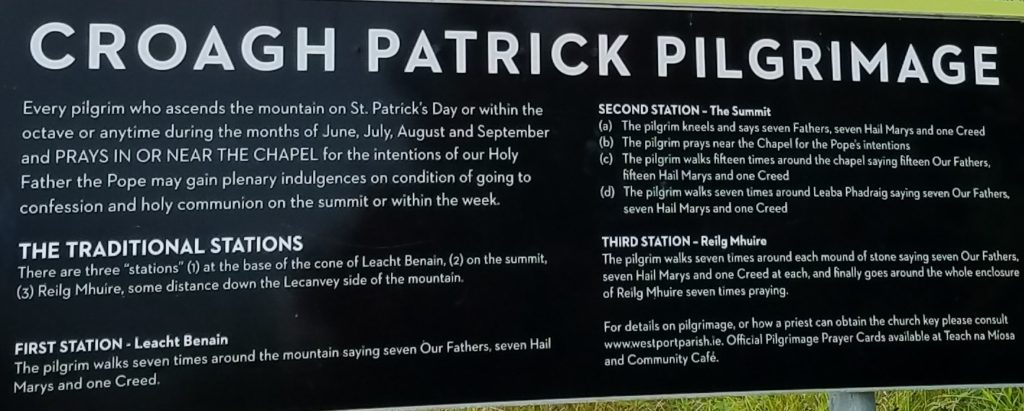
This sign at the bottom of the trail describes activities required to complete the Croagh Patrick “pilgrimage”. I heard that some pilgrims even make the hike barefooted! I completed the hike, but not the pilgrimage requirements.
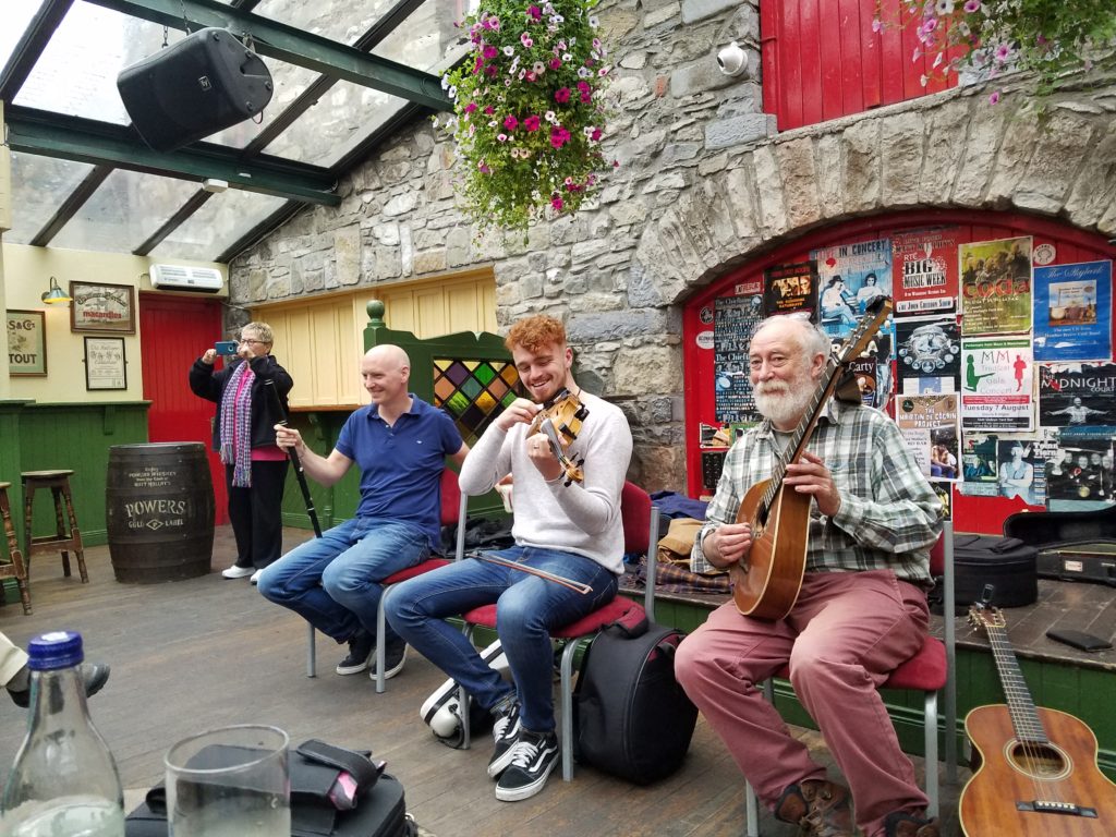
After the hike, I had lunch with my mom in Westport. That evening, our tour group enjoyed a private concert of live traditional Irish music at Matt Molloy’s pub, with Peter Molloy (flute), Joseph O’Leary (fiddle, bodhran), and Tony Reidy (guitar, vocals).
musicians tuning up at Matt Molloy’s pub; mom in background snapping photo